Where should you go skiing this weekend?! Tetsuji Hyodo, "Japan's best skiing weather forecaster," predicts the powder snow this weekend.
Weekend Overview
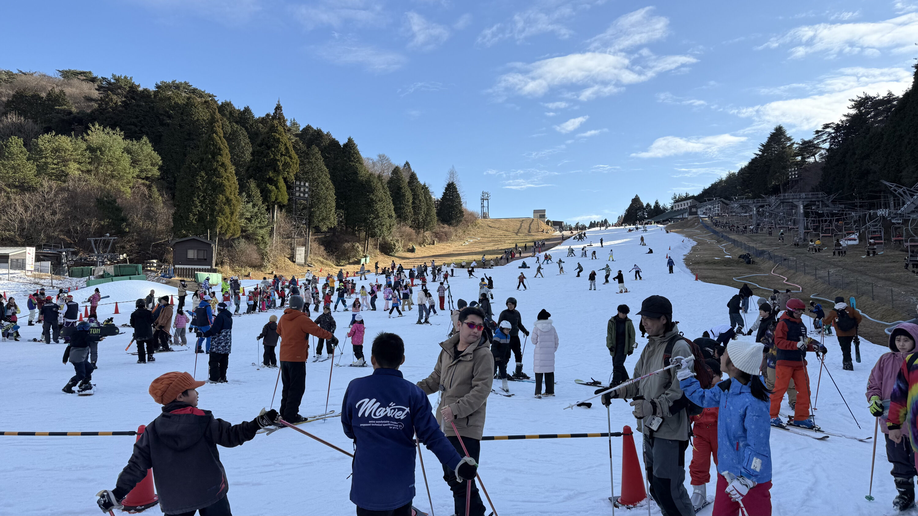
Happy New Year 2026, everyone! We've been blessed with snow since the end of the year, and many people have already had their first skiing experience of the year, so I'm sure 2026 has started off great for them. And it looks like the snow will continue into the new year. So, let's take a look at the forecast!
A winter-like atmospheric pressure pattern has been in place since the end of the year. This pattern is expected to continue through the next 3 days. In particular, on the 2nd, extremely cold air with temperatures below -39°C is expected to flow into Japan at around 5,500m above sea level, bringing heavy snowfall not only to northern and eastern Japan, but also to western Japan from the 2nd to the 3rd
In backcountry (BC) areas, beware of avalanches caused by heavy snowfall and growing snowdrifts. There is also a possibility of traffic restrictions and disruptions to public transport due to worsening road conditions, so be sure to check traffic information along with the weather forecast. Snow is expected to intensify in western Japan in the afternoon of the 2nd. For this reason, even if you are able to access the slopes without any issues on the morning of the 2nd, you will likely need to be careful on your way back the following day
Through Friday, January 2nd

Heavy snow is expected to fall from the Sea of Japan side of northern Japan to Joetsu from January 1st to the morning of the 2nd, with snowfall of around 30 to 50 centimeters expected
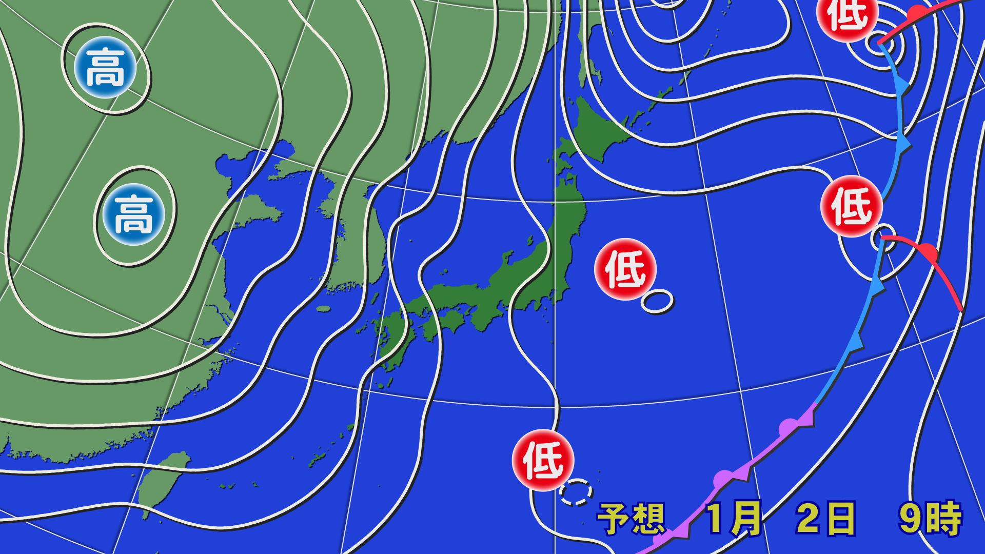

A winter-like atmospheric pressure pattern will continue during the day on the 2nd, bringing widespread snowfall. A low-pressure trough is forming from the western Sea of Japan to the sea east of Kanto, creating a convergence line, and very strong cold air is flowing into the sky, so snow is expected to intensify in western Japan in the afternoon. There is also a risk of snowfall in the cold winter plains, so please be aware of disruptions to transportation
[Hokkaido area]
A low-pressure trough will pass through on the night of January 1st, bringing blizzards. Heavy snow is expected in Niseko and the central Hokkaido area through the morning of the 2nd. Northwesterly winds are expected to blow during the day on the 2nd, with wind speeds in the mountains settling to around 10 m/s. Snow will fall during the day, mainly on the Sea of Japan side of central and northern Hokkaido. Temperatures are expected to remain below freezing during the day, making it possible to enjoy powder snow
[Tohoku area]
The night of January 1st will be windy and produce a blizzard. Heavy snowfall is also expected along the Ou Mountains, so the morning of the 2nd will be a battle for powder snow. The wind will calm down during the day tomorrow, and will be weak except in areas along the Sea of Japan. Snow will fall on and off near the Ou Mountains, with occasional sunshine. Temperatures are expected to remain below freezing along the mountains during the day, and the snow quality looks good
[Yuzawa area]
Heavy snowfall is expected from the night of January 1st through the morning of the 2nd. It looks like we'll be able to enjoy some solid powder snow. The wind and snowfall will calm down somewhat during the day on the 2nd. However, the snow is expected to get heavier at night, so please be careful if you're returning home late or staying overnight. Temperatures will likely remain below freezing. There may be occasional periods of sunshine
[Shinetsu area]
It looks like there will be a lot of snow by the morning of the 2nd. We can expect relatively dry powder. Snow is expected to continue falling during the day on the 2nd. The wind will not be very strong. Please be careful of traffic congestion due to heavy snow when returning home in the evening
[Joetsu area]
There will be a lot of snow on the night of January 1st. Deep powder is expected on the morning of the 2nd, but please be aware of traffic restrictions and allow plenty of time when heading out. The wind is not very strong, but snow is expected to continue during the day, so it looks like there will be more powder, and it will be endless
[Other areas]
Snow is expected to fall from the evening of January 1st on the Sea of Japan side of western Japan, as well as in Kyushu and Shikoku by the 2nd. The snow will not be particularly heavy in the morning of the 2nd, but is expected to suddenly get heavier in the afternoon. Please be careful not to get into trouble on your way home, and it is a good idea to prepare supplies to prevent getting stuck, as well as water and food, just in case
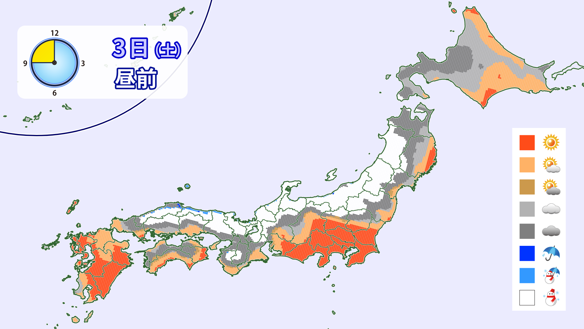
Through Saturday, January 3rd
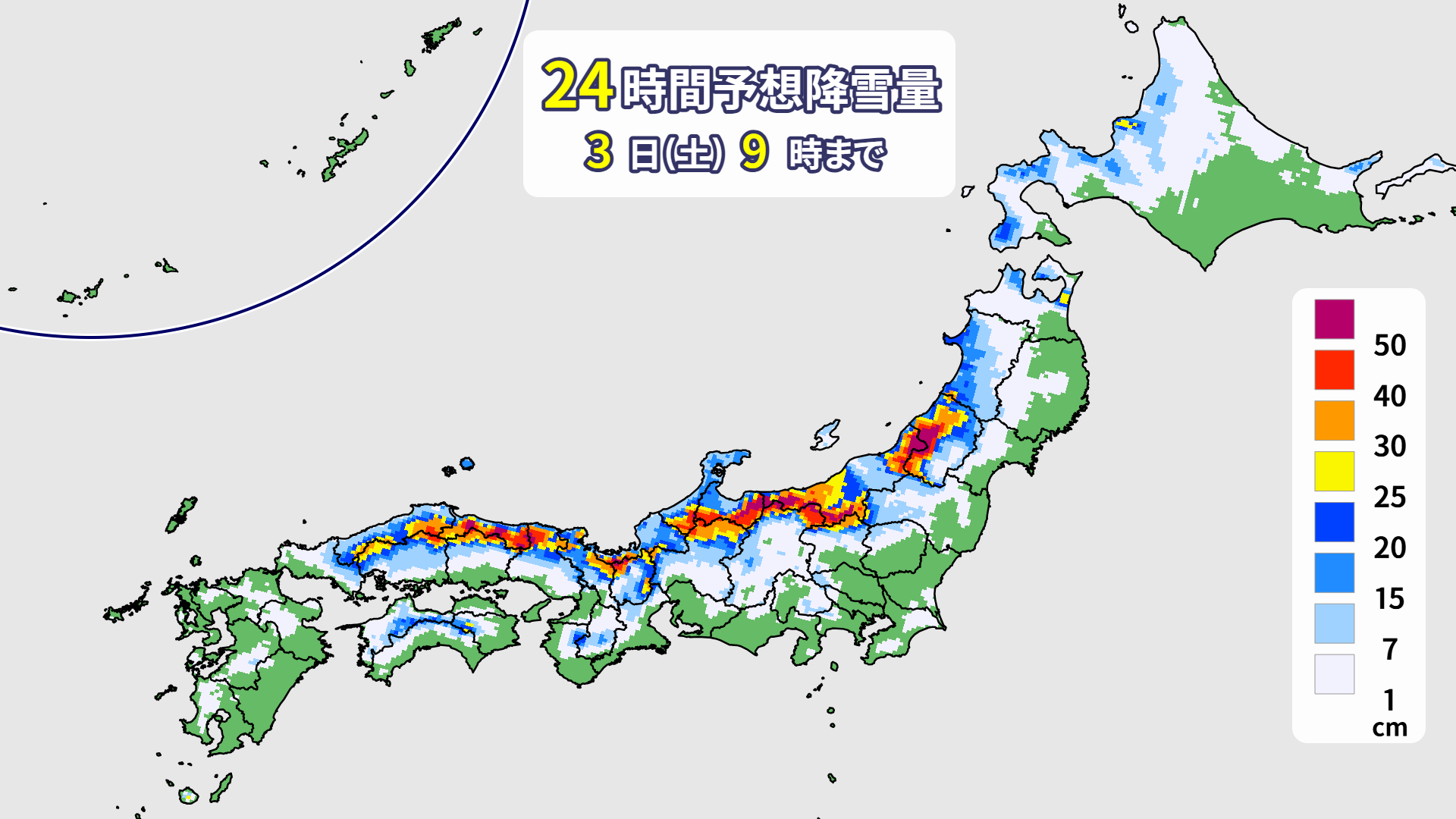
In some mountainous areas in western Japan, snowfall of more than 50 centimeters is expected between the middle of the day on the 2nd and the morning of the 3rd. It is possible that snow removal work will not be able to keep up, so please check the latest weather information as well as traffic information
[Hokkaido area]
Snowfall of about 10 to 20 centimeters is expected from the night of the 2nd. A weak winter-type atmospheric pressure pattern will prevail during the day. Northwest to west winds will blow, but they will not be very strong, and the snow is expected to stop by the afternoon. It looks like it will be comfortable throughout the day
[Tohoku area]
Several tens of centimeters of snow is expected to accumulate, mainly in the Sea of Japan side of Yamagata. Snow accumulation of around 10 to 20 centimeters is also expected along the Ou Mountains. Westerly winds will be somewhat strong, with winds of around 10 m/s possible. Snow is expected to continue mainly in areas hit by westerly winds. Blizzards are expected in the mountaintop area
[Yuzawa area]
Heavy snow is expected to continue through the morning of the day after tomorrow. It may accumulate to nearly 50 centimeters. Northwesterly winds are expected to be somewhat strong during the day, with snow continuing to fall at speeds of around 10 m/s. Powder snow is expected to be enjoyable throughout the day, but the summit area will likely experience heavy snowfall. Please be aware of traffic restrictions
[Shinetsu area]
As cold air intensifies in the upper atmosphere, snowfall is expected to increase dramatically from the night of the 2nd. Heavy snowfall exceeding 50 cm is also expected in some areas by the morning of the 3rd. The snowfall will ease somewhat during the day, but the snow will come and go, and there may be blizzards in the mountaintop area
[Joetsu area]
We are expecting around 50cm of snowfall from the night of the 2nd to the morning of the 3rd. It is likely to accumulate quite a bit. The snow will come and go during the day, and the wind will be only slightly strong in Hakuba, but there is a possibility of blizzards in Myoko
[Other areas]
In western Japan, heavy snowfall is expected to begin in the afternoon of the 2nd. On the 3rd, you can fully enjoy the feeling of fresh snow. The peak of the snow will have passed, but snow will fall on and off mainly in the mountains from Kinki to San'in, and winds will blow somewhat strongly
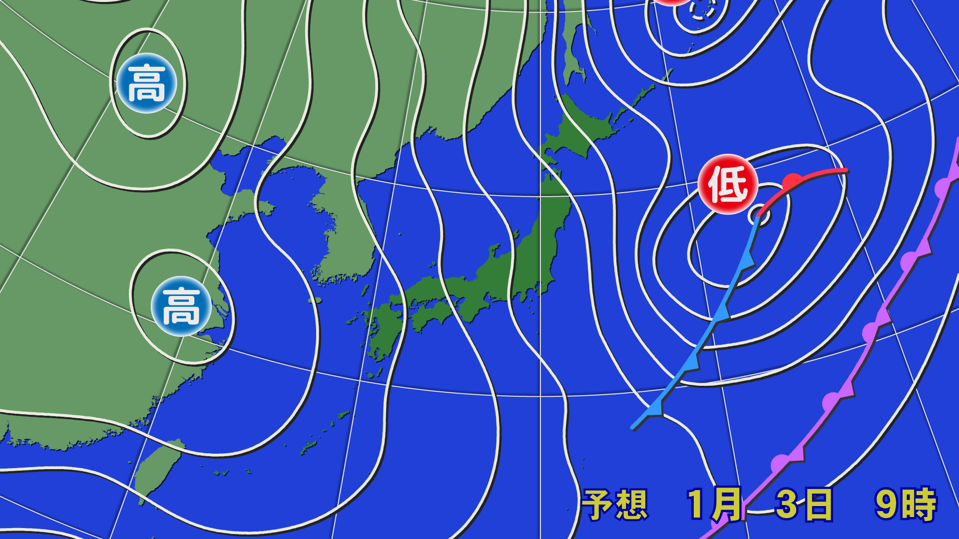
Through January 4th (Sunday)

The snow is expected to peak by the night of the 3rd, but further snow will accumulate in mountainous areas. Snowfall of 10 to 20 centimeters is expected in many areas. The snow will narrow during the day, but the passage of a low-pressure trough is expected to temporarily intensify snowfall in some areas of Hokuriku and Tohoku

[Hokkaido area]
Snow will begin falling around midnight on the 4th as a low-pressure trough passes through. Strong westerly winds are expected to blow during the day. The snow will not be very strong, but it is expected to fall on and off
[Tohoku area]
Heavy snow is expected in Asahi and the Iide Mountains area through the morning of the 4th. Snow will fall on and off during the day due to the influence of a low pressure trough. The snow may intensify temporarily. The snow quality is expected to be somewhat wet
[Yuzawa area]
The amount of snow accumulation in the morning will be less than that up until the 3rd. It will be cloudy during the day with some sunshine. Due to the influence of a low pressure trough, snow may start falling in some areas at night. Winds will be calm
[Shinetsu area]
There will likely be only a slight accumulation of snow by the morning of the 4th. There will likely be some sunny spells in the morning. It will be cloudy in the afternoon, with a chance of snowfall at night. The wind will be calm, making for a comfortable day
[Joetsu area]
A light snowfall will occur. It will be cloudy in the morning with some sunshine. Snow is expected to fall on and off again in the afternoon. The wind will be weak and there is no chance of a blizzard. The snow will be slightly wet
[Other areas]
In western Japan, the winter pressure pattern will ease and the snow will stop. It will likely be cloudy with some sunshine during the day. The snow will also loosen up a bit. A soft, water-repellent wax would be a good choice
At the end
December 29th was my last day of skiing. Since I'm back in my hometown, I went to Rokko Mountain Snow Park (when I used to go there, about 30 years ago, it was called Rokko Mountain Artificial Ski Resort), where I skied for the first time in my life. I started skiing because there was a ski resort in Kobe, where snow rarely falls, so it's quite moving to think that this is connected to writing this article. I'd like to return to Yamagata and go to Zao Onsen Ski Resort for my first skiing experience
It looks like there will be a lot of snow in the coming days, especially in the first half of January, so be sure to prepare well and have fun! Thank you for your continued support this year