
Where should you go skiing this weekend?! Tetsuji Hyodo, "Japan's best skiing weather forecaster," predicts the powder snow this weekend.
Overview of this weekend
We've had some great snow since the start of the year, so I hope everyone enjoyed some fulfilling New Year's snow rides. As for the weather this weekend, it looks like it'll be one where you'll have different ways to enjoy it every day. Check the weekend powder forecast and have a great weekend!
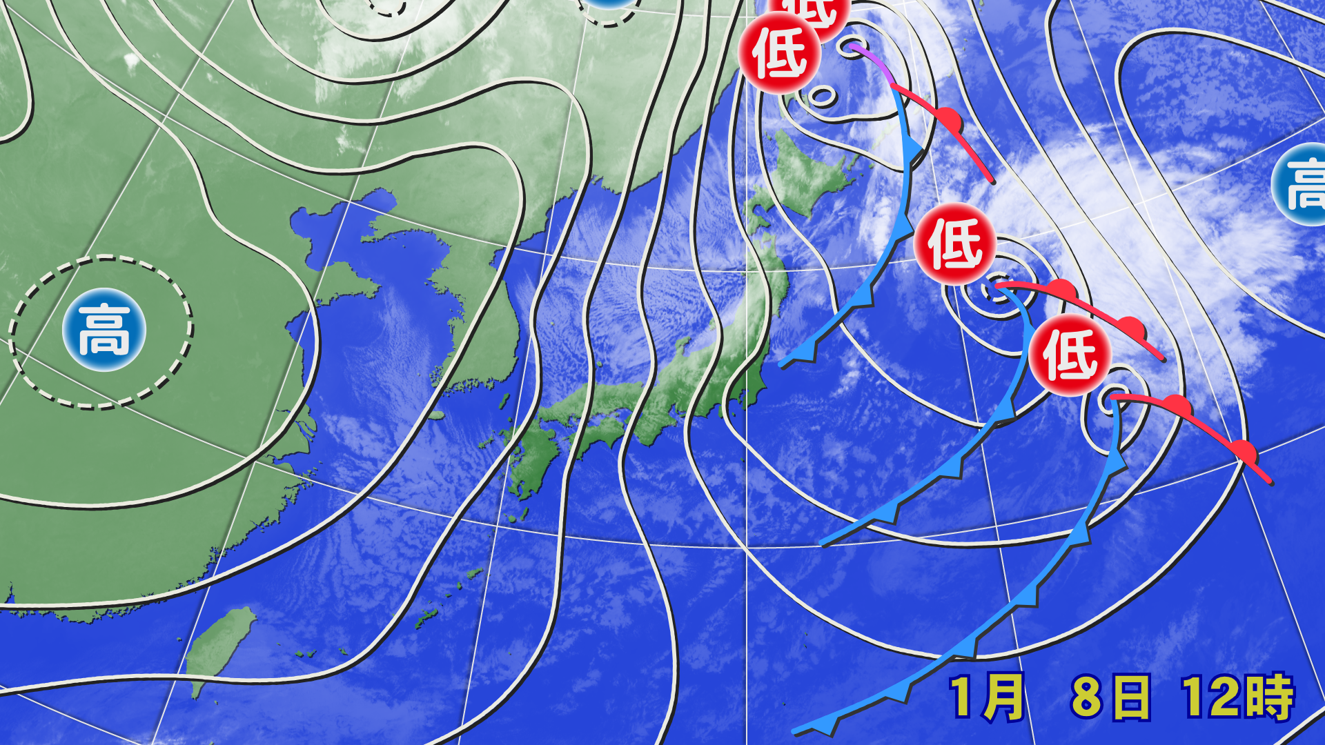
A winter pressure pattern is occurring around Japan. Snow and blizzards are occurring along the Sea of Japan side, mainly along the mountains, and fresh snow is expected along the Sea of Japan side by the morning of Friday, January 9th. The snow will gradually stop during the day due to a mobile high pressure system
On Saturday, January 10th, a high pressure system will pass through and a low pressure system will approach, with sunny skies expected across most areas except Hokkaido and northern Tohoku. The conditions will be pleasant for beginners and families. However, southerly winds blowing toward the low pressure system will gradually strengthen. In high-altitude areas, the winds may affect the operation of gondolas and lifts
On Saturday night, a low pressure system and front will pass, bringing temporary rain to many areas, raising concerns about worsening snow conditions. On Sunday, the pressure pattern will shift to a strong winter pattern, bringing snow and heavy blizzards across a wide area from western to northern Japan. Extremely cold air with temperatures below -39°C is expected to flow in around 5,000 meters above Wajima, creating a developed snow cloud band known as the "JPCZ." This may move toward the Tohoku and Hokuriku regions, bringing the risk of heavy snow. In addition to checking the operation status of lifts and gondolas, please be aware of disruptions to public transportation, such as traffic jams
Through Friday, January 9th

The winter pressure pattern and cold air will continue to influence the night of Thursday, January 8th, so some fresh snow will accumulate by the morning of Friday, January 9th. High pressure will extend during the day, so the snow will gradually stop. Some sunny spots are expected


[Hokkaido area]
Heavy snow fell around Sapporo today, January 8th (Thursday). Snow will continue tonight, mainly in the Niseko and Sapporo areas, with about 10 centimeters expected to accumulate by morning. The snow is expected to stop during the day on January 9th (Friday), but some strong westerly winds are expected to remain. There is a possibility of blizzards and ground blizzards in high-altitude areas
[Tohoku area]
Snowfall will continue tonight, Thursday, January 8th, mainly along the Sea of Japan side, with around 10cm of snow expected to accumulate. The morning of Friday, January 9th will also be cold, so we should be able to enjoy light, dry powder. The snow is expected to weaken during the day, but winds from above will remain, so some areas on the Sea of Japan side at high altitudes will likely see snow. Winds will also be somewhat strong, with winds of around 10m/s expected in some high-altitude areas
[Yuzawa area]
Snow is expected to fall into the morning of Friday, January 9th, with about 10 to 20 centimeters expected to accumulate. You'll be able to enjoy some solid powder. The snow will stop during the day, and there will be periods of sunshine. The wind will also die down, making for comfortable skiing
[Shinetsu area]
Snow is expected to fall toward dawn on Friday, January 9th. It will likely only accumulate lightly. The snow will likely be light. The snow will stop during the day and the skies will clear up. The wind will be weak, making for comfortable skiing
[Joetsu area]
Snow will fall until dawn on Friday, January 9th. It will only accumulate lightly. There will be sunny skies during the day. There will be no wind, so it should be comfortable to ski
[Other areas]
It is likely that snow will accumulate in northern Kinki and Sanin. Friday, January 9th will be sunny in most areas
Through Saturday, January 10th

Starting the night of Friday, January 9th, snow is expected to fall in some areas of Hokkaido and northern Tohoku, but due to the inflow of warm air, the snow will be wet and not accumulate significantly. A low pressure system will develop and move across the Sea of Japan, bringing strong southerly winds and unseasonably warm air, with the 0°C line around 1,500m moving northward to northern Tohoku. Snow and rain are expected in Hokkaido and northern Tohoku during the day, and rain is expected from Honshu southward at night


[Hokkaido area]
A low pressure trough will bring some snow from the night of Friday, January 9th, but it will not accumulate much. Snow is expected during the day on Saturday, January 10th, but it is likely to be wet snow for Hokkaido. We recommend using wax that is softer than usual and provides good glide. Winds are also expected to be somewhat strong on the southern slopes, reaching around 10 m/s in some areas
[Tohoku area]
On the night of Friday, January 9th, some areas of northern Tohoku will see wet snow. It may turn into sleet. Rain and snow are expected in northern Tohoku during the day on Saturday, January 10th. Slope conditions are likely to deteriorate. Temperatures will rise in southern Tohoku, but it will be sunny during the day. The snow is likely to loosen, so we recommend using wax for better glide. Rain is expected to fall at night
[Yuzawa area]
Saturday, January 10th will be sunny. It will be chilly in the morning, so the packed runs will be firm and comfortable. As the day progresses, temperatures will rise, and the snow quality is likely to deteriorate. Southerly winds will gradually strengthen, so it's best to enjoy higher elevation areas in the morning
[Shinetsu area]
Saturday, January 10th will also be sunny. As temperatures rise during the day, the snow quality is likely to deteriorate, especially on south-facing slopes. If you're looking for good snow quality, aim for the north-facing slopes
[Joetsu area]
Saturday, January 10th will be sunny. Carving on the groomed runs will be pleasant in the morning. The snow will gradually loosen during the day. There is a possibility of strong downwind winds from the south in the Niigata Prefecture area
[Other areas]
It will be mostly sunny during the day on Saturday, January 10th. Strong southerly winds are expected in western Japan. Please be aware of lift operation status
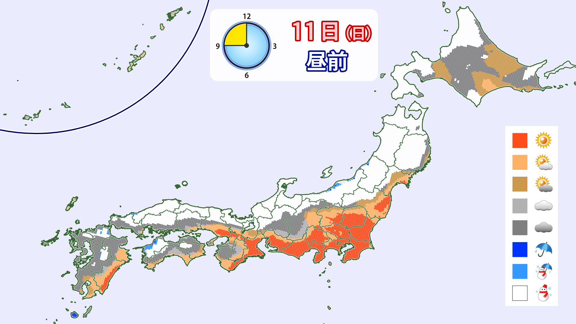
Through January 11th (Sunday)

The developed low pressure will move towards Primorsky Krai, passing through a cold front and creating a strong winter pressure pattern around Japan. Rain will be expected in many areas until around the time the date changes to Sunday, January 11th, but it is expected to change to snow nationwide by the morning
Due to strong winds blowing across the country, some ski resorts are likely to shut down their lifts. The JPCZ is expected to form and move toward northern Tohoku in the morning. It will gradually move south during the day and head toward the Hokuriku region. Areas affected by the JPCZ will experience heavy snowfall, so please be careful of accidents while skiing due to poor visibility. Also, be careful of accidents and traffic disruptions when going to and from ski resorts
[Hokkaido area]
On Saturday, January 10th, there will be rain in some areas on the plains overnight. A heavy snowstorm is expected during the day on Sunday, January 11th. Lifts and gondolas may stop running, and even if they do, it may be difficult to enjoy them
[Tohoku area]
Rain is expected overnight on Saturday, January 10th. Low-altitude areas will experience granular snow, while higher elevation areas will experience icy conditions. On Sunday, January 11th, heavy snow will fall in some areas during the day. Lifts may be stopped due to poor visibility and heavy snow
[Yuzawa area]
Rain will change to snow during the night on Saturday, January 10th. Snow is expected to continue during the day on Sunday, January 11th, creating endless powder. Slope conditions are likely to be poor first thing in the morning, but will improve as the snowfall progresses
[Shinetsu area]
On Sunday, January 11th, high-altitude areas such as Shiga Kogen will likely see no rain and good conditions. Snow will likely fall on and off during the day. Conditions are likely to be relatively good for skiing, but if the westerly wind strengthens, lifts may be shut down
[Joetsu area]
On Sunday, January 11th, strong winds will blow from the west, causing heavy rain. Due to the strong winds, some ski resorts may have difficulty opening their slopes. Please check the slope information before setting off
[Other areas]
Snow is expected to fall on Sunday, January 11th, including in Kyushu and the Pacific coast. Due to strong winds, some slopes may not be open. Please also be sure to check road information and take care to avoid accidents and traffic disruptions
lastly
Now that January has arrived, we're finally seeing substantial snowfall. There will be many snowy days through next week, but the snowfall is expected to calm down a bit after that. If you're looking for powder snow, make sure to enjoy the period leading up to next week!
