
Where should you go skiing this weekend?! Tetsuji Hyodo, "Japan's best skiing weather forecaster," predicts the powder snow this weekend.
Weekend Overview
This weekend, long-awaited snow will fall from northern to western Japan! Make sure you plan ahead
Through Friday, December 26th

On Friday, December 26th, a winter-like atmospheric pattern will develop across the country, bringing widespread snowfall, especially along the Sea of Japan coast. Cold air with temperatures of -6°C at around 1,500m is expected to move south to the Pacific coast. As strong cold air moves south, we can expect good quality powder snow. Ski resorts in western Japan will also see substantial snowfall
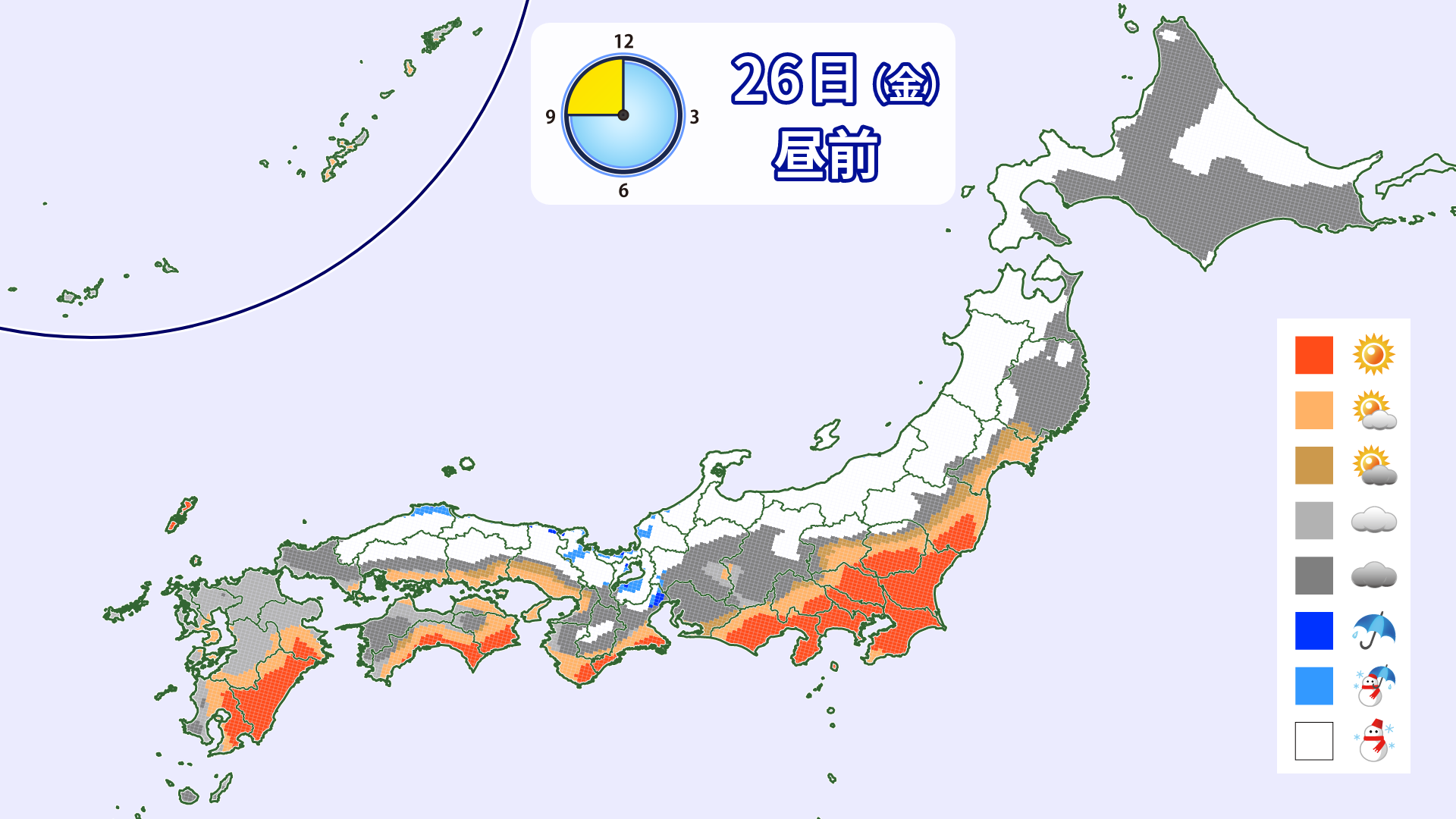

[Hokkaido area]
There will not be much snow falling on the night of Thursday, December 25th. On Friday the 26th, snow will fall mainly in eastern Hokkaido. Snow is expected to fall mainly in areas on the Sea of Japan side during the day, with the snow expected to intensify in the afternoon. Winds will also strengthen, causing blizzards in some areas. Cold air with temperatures below -10°C will be moving in around 1500m, so it looks like we will be able to enjoy the finest powder snow in all areas
[Tohoku area]
The snow along the mountains will stop overnight on the 25th (Thursday), but will start falling again from dawn on the 26th (Friday). In the morning, there will be heavy, wet snow, mainly along the mountains on the Sea of Japan side. In the afternoon, it will change to powder and continue falling. However, strong winds are expected, with wind speeds of around 20 m/s expected in high-altitude areas and on the summit. Lifts may be closed
[Yuzawa area]
Heavy snow will fall suddenly from the early hours of Friday the 26th. It is expected to be particularly heavy in the morning. The snowfall is expected to ease in the afternoon. As there is a possibility of significant snowfall, please check in advance to confirm business hours
[Shinetsu area]
Heavy snow is expected to fall on the morning of Friday the 26th. Snow will fall on and off throughout the day. Winds are not expected to be too strong in the Shinetsu area, which is slightly inland, so you can enjoy high-quality powder snow throughout the day
[Joetsu area]
Snow will begin falling on the night of Thursday the 25th, with heavy snowfall on the morning of Friday the 26th. Business openings may be delayed. Northerly winds will be somewhat strong in the morning. The wind is expected to calm down somewhat in the afternoon
[Other areas]
From the evening of Thursday the 25th to Friday the 26th, we can expect heavy snowfall from the Kinki region to Sanin. Enjoy the feeling of fresh snow
Through Saturday, December 27th

In northern Japan, the winter pressure pattern will continue, and snow will continue. Westerly winds are expected to continue. In eastern and western Japan, the winter pressure pattern will gradually weaken
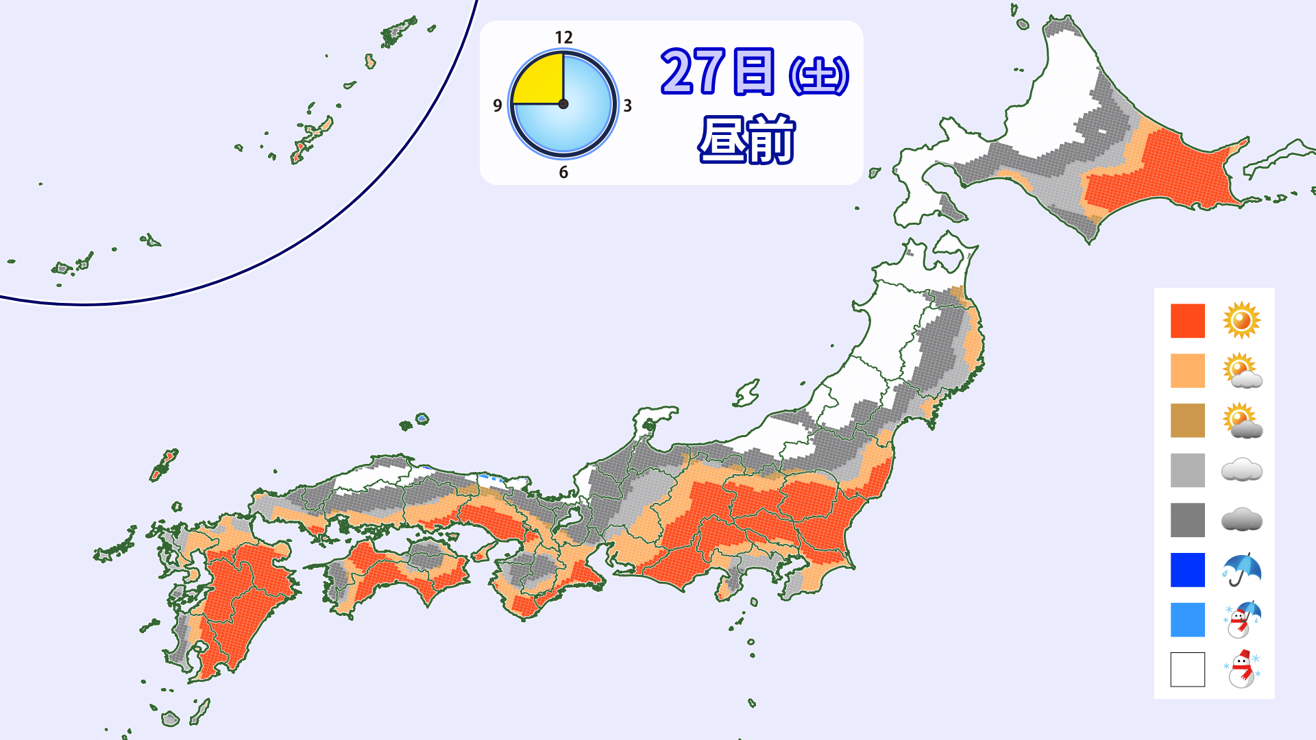

[Hokkaido area]
The wind will shift to a westerly direction, and snow and blizzards will continue, mainly in areas along the Sea of Japan coast. Wind speeds are expected to be around 15 m/s around 1,500 m. It is important to check the operating status of lifts
[Tohoku area]
The snow will continue to fall on and off, so you can enjoy endless powder snow. Wind speeds are expected to be around 15m/s around 1500m, so please be aware of lift operation status
[Yuzawa area]
Snow will fall on and off in the morning. It is expected to be cloudy in the afternoon. With plenty of snow from the previous day and low temperatures, conditions should be good throughout the day. There will be wind, but wind speeds are expected to be less than 10 m/s
[Shinetsu area]
It will be cloudy during the day, with occasional snow in the morning. The snow is expected to stop in the afternoon. The wind will also be weak. It looks like we will be able to enjoy good snow conditions
[Joetsu area]
It will be mostly cloudy during the day, with light winds and the best powder snow
[Other areas]
There will only be a light dusting of snow during the day. The temperature is low, so the conditions look good
Through Sunday, December 28th
Hokkaido will remain under a winter pressure pattern in the morning, but it will gradually ease. Honshu will be covered by a high pressure system, and some areas will be sunny
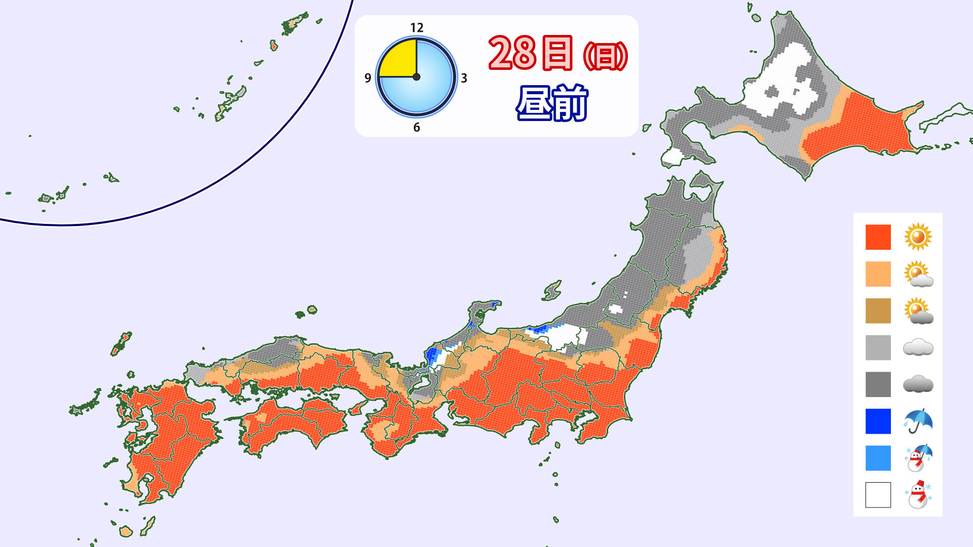

[Hokkaido area]
Snow will fall on the Sea of Japan side in the morning. It is expected to stop by the afternoon. Strong westerly winds are expected with winds of nearly 15 m/s around 1,500 m
[Tohoku area]
Snow will fall on and off in the mountains, mainly in the morning. Winds will remain strong from the west, with winds of 10-15 m/s around 1500 m
[Yuzawa area]
There will likely be some snow in the morning. The afternoon will be sunny. The conditions are expected to remain good until the end
[Shinetsu area]
It will be partly sunny and partly cloudy. The temperature is low, so the conditions look good
[Joetsu area]
It will be mostly sunny. Enjoy the spectacular views and snow
[Other areas]
It will be mostly sunny, but the snow will likely ease up a bit in the afternoon
At the end
There was no snow last week, and many ski resorts struggled to stay open this week until Thursday, December 25th, but it looks like some will be able to make a comeback this weekend and even open a new one. While not much snow is predicted for the end of the year, a strong cold wave is predicted for the start of the new year. Whether you're heading out to ski this week or haven't yet started your season, January is likely to be a good time to get ready for more powder opportunities
