
Where should you go skiing this weekend?! Tetsuji Hyodo, "Japan's best skiing weather forecaster," predicts the powder snow this weekend.
Read this weekend's overview
Tomorrow, Friday, December 12th

Tonight, a low pressure system is expected to develop and pass through Hokkaido, moving toward the Kuril Islands. A cold front will pass through Honshu, and tomorrow, a winter-type pressure pattern will strengthen over northern and eastern Japan. As a result, snow and blizzards are expected in Hokkaido and along the Sea of Japan.

What about Saturday, December 13th?

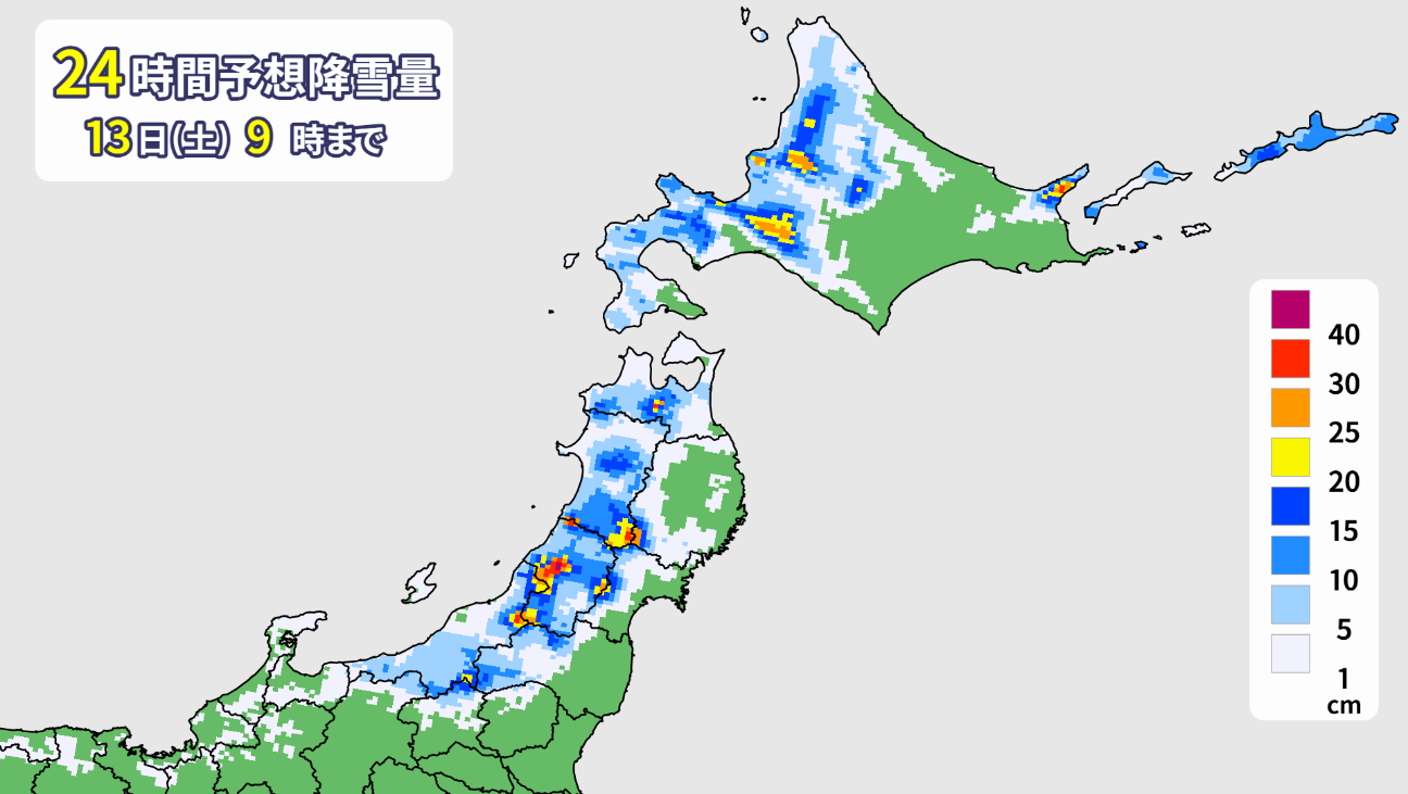
The winter pressure pattern will weaken from the west, but northern Japan will remain affected by the cold air. As a result, snow is expected to fall in some areas, mainly on the Sea of Japan side of northern Japan. Low pressure systems are also expected to form on the Sea of Japan side and the Pacific side of western Japan, and will develop and move eastward. Rain and snow will also fall in eastern Japan late at night.
What about Sunday, December 14th?
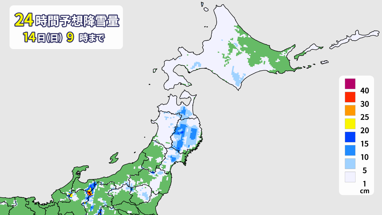
The two low pressure systems are expected to develop and move forward, with the one on the Sea of Japan side heading toward Hokkaido and the one on the Pacific side moving toward the Kuril Islands through the coast of Sanriku. Snow and rain are expected to fall in eastern and northern Japan. Heavy snow is also expected in some areas of the Pacific side of Tohoku and eastern Hokkaido.
Snowfall forecast by area
Hokkaido area
An extremely cold front will cover the area through Saturday (13th). We can expect exceptionally dry powder. More than 30 centimeters of snow is expected to fall in Niseko, Rusutsu, and even Furano through tomorrow. Beware of strong winds from the west through Saturday morning. The wind and snow will calm down overnight, but a low pressure system will approach eastern Hokkaido from Sunday morning, bringing heavy, wet snow and blizzards.
Tohoku area
A strong winter pressure pattern will be in place through tomorrow (Friday the 12th), so we can expect good quality powder at Appi Kogen, Zao Onsen, Nekoma Mountain, and other areas. Around 20 to 30 centimeters of snow is expected to accumulate on the top slopes through tomorrow. Strong winds from the north will cause blizzards, so be sure to check lift operation and transportation information.
It will snow in the morning on Saturday. The wind will gradually die down, and we can expect sunny skies from around noon. At night, a low pressure system will move off the coast of Sanriku, bringing in warm air for a while, which could result in sleet or rain on Sunday morning. Beware of worsening ski slope conditions. The weather will be changeable with sunny spells, and will turn to snow again in the afternoon.
Yuzawa area
Heavy snow and powder are expected tomorrow morning (Friday the 12th). Snowdrifts could be over 50cm deep. Snow will continue to fall throughout the day, creating endless powder. However, due to strong winds, it's important to check lift operation status. Saturday will be sunny, possibly the "Day," making for a fantastic snow experience. The weather will be changeable on Sunday. Rain and wet snow are likely, but there may also be some sunshine.
Shinetsu (including Nagano, Hakuba, and Shiga)
Heavy snowfall of over 30 cm is expected by tomorrow morning (Friday the 12th). Strong winds are expected tomorrow, and there is a possibility of lift closures. Please check operation information. The wind will die down on Saturday and it will be sunny. If Friday is closed, it will be a good day to enjoy the finest powder. On Sunday, it will likely be rainy at the base, with a mixture of snow at the top. The weather is expected to be changeable, with rain and clear skies.
Joetsu area (Myoko, Arai, etc.)
There is a possibility of heavy snowfall of over 50 cm through tomorrow (Friday the 12th). Tomorrow will be a windstorm, so be sure to check the lift operation status. The wind is expected to die down a bit tomorrow afternoon. Saturday will be sunny, allowing for spectacular snow-snowing. Sunday is expected to be unsettled due to the influence of a low pressure system. There is a chance of snow and sleet at the top, and rain at the base.

lastly
Last weekend, I finally got to ski for the first time! I went skiing at the pre-opening of my local Zao Ski Resort. As you can see, the trees were covered in snow and completely white. There might be even more powder this weekend! Everyone, please head to the snowy mountains based on the powder forecast!