Where should you go skiing this weekend?! Tetsuji Hyodo, "Japan's best skiing weather forecaster," predicts the powder snow this weekend.
Overview of this weekend
As predicted, a cold wave is coming. The cold wave will continue into this weekend, so snow will likely fall in the mountains almost every day. However, continued snowfall may make it difficult to access ski resorts and mountains. Please be sure to prepare the necessary gear and check the roads
Additionally, the risk of avalanches is high in the backcountry due to heavy snowfall. Please be sure to check your snowy mountain gear, the latest information, and manage risks appropriately. A winter-like atmospheric pressure pattern will continue through Sunday, but the areas with the most snow are likely to change, so let's take a closer look
Through Friday, January 23rd
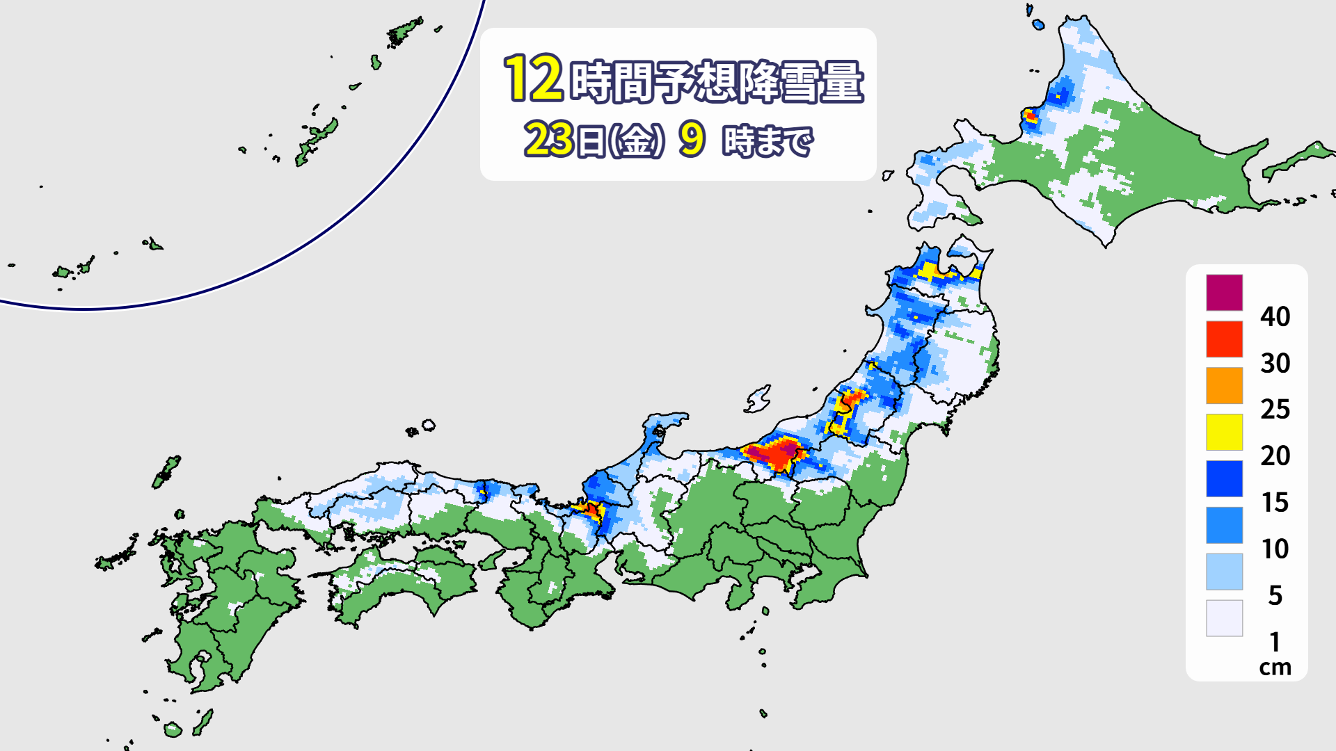
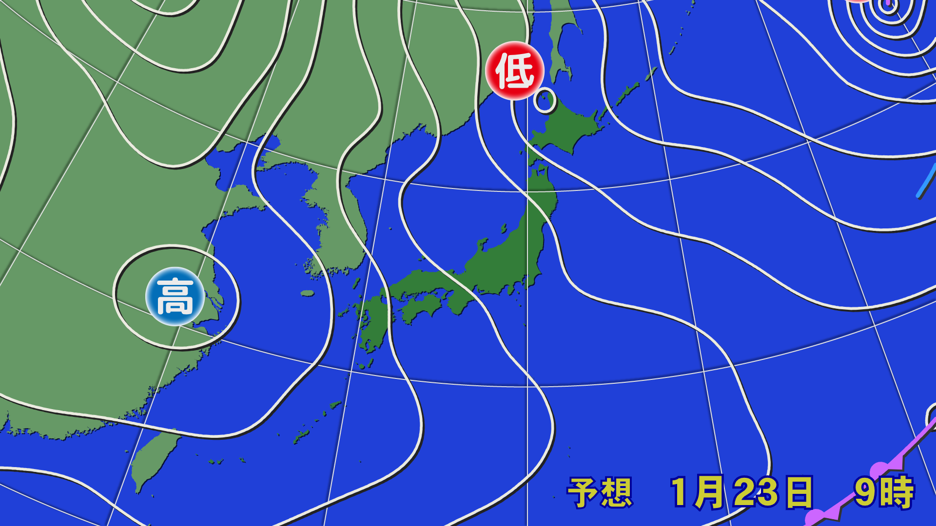
A small low pressure system will form on the Sea of Japan side of Hokkaido on the night of Thursday, January 22nd, and is expected to approach Hokkaido tomorrow. Additionally, the Japan Sea Polar Air Mass Convergence Zone (JPCZ) will move toward the Wakasa Bay area tomorrow morning, and toward the Hokuriku region at night. Westerly winds will continue in the Tohoku region through tomorrow

[Hokkaido area]
Snow is expected to fall mainly along the Sea of Japan coast as westerly winds blow through Friday the 23rd. Heavy snow and stormy weather is possible in the Rumoi and Soya regions, which are close to a small low pressure system, so please be careful of lift operation. Light fresh snow is expected to accumulate in Niseko and other areas by tomorrow morning
[Tohoku area]
On Friday the 23rd, strong westerly winds will continue to bring snow and blizzards. Although the wind will be strong, there will likely be occasional sunshine. Significant snow is expected tonight, with around 20 centimeters of fresh snow expected to accumulate by morning
[Yuzawa area]
On Friday the 23rd, southwesterly and northwesterly winds are expected to converge in the Chuetsu region, causing snow clouds to form. Tonight, heavy snow is expected at Mount Hakkai and other areas, rather than at Naeba and Kagura, which are located to the south of the area, and the heavy snow is expected to continue through the day tomorrow. In some cases, there may be delays in opening or closures, so please check the information released by ski resorts carefully
[Shinetsu area]
On Friday the 23rd, we will be south of the aforementioned JPCZ, so it will likely be cloudy or sunny. However, if the convergence zone shifts south, there is a possibility of snow. There will be little snow tonight, and only a light accumulation tomorrow morning
[Joetsu area]
On the morning of Friday the 23rd, the JPCZ will move toward the Wakasa Bay area, creating a relatively high pressure area, resulting in weak winds and cloudy to sunny skies. Not much snow is expected to fall tonight either
[Other areas]
The JPCZ is expected to move toward the Wakasa Bay area by the morning of Friday, the 23rd, and gradually move toward the Hokuriku region tomorrow. Heavy snow is expected to fall tonight in Oku-Ibuki and Mount Washigatake, and snow will continue tomorrow. Western Japan is also expected to see fresh snow accumulation by tomorrow
Through Saturday, January 24th
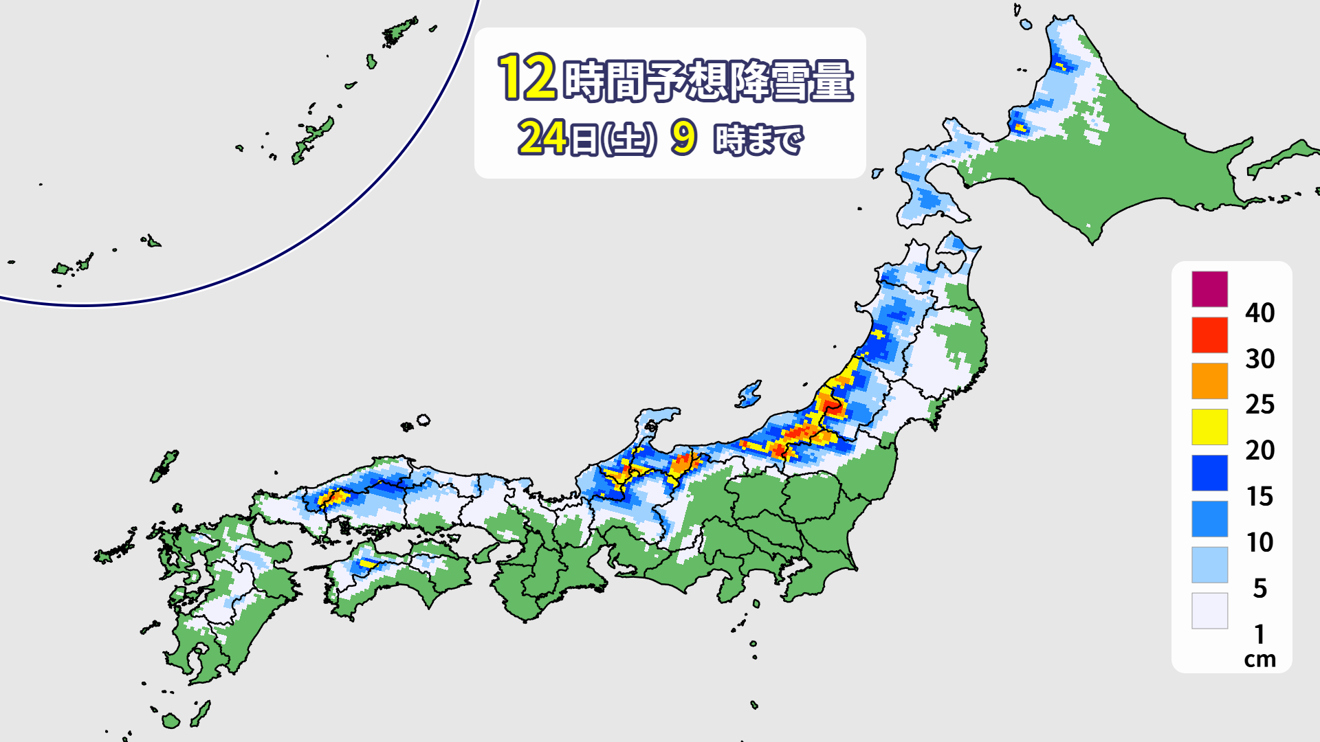
On Saturday the 24th, the JPCZ is expected to move from Hokuriku to southern Tohoku. Heavy snowfall will be expected along the Sea of Japan coast, while some inland areas will see little snow
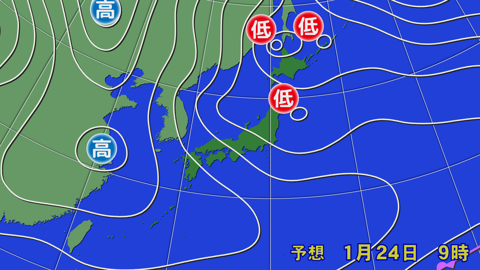

[Hokkaido area]
A new small low pressure system has formed in the northern Sea of Japan and is expected to gradually approach. It is currently not expected to approach during the day, so it is not expected to cause severe storms, but please check the latest forecast. Many areas along the Sea of Japan side are expected to see around 10 centimeters of snow since the previous night
[Tohoku area]
On Saturday the 24th, the JPCZ is expected to move towards Yamagata Prefecture from dawn until the morning. There is a chance of heavy snowfall for a time in the mid-western part of Yamagata Prefecture and the Aizu region of Fukushima Prefecture. Even by morning, some areas are likely to see 20 to 30 centimeters of snow accumulation. Meanwhile, northern Tohoku and the Ou Mountains are not likely to see much snow, and there may be sunny spells. Even by morning, the snow accumulation will not increase significantly in northern Tohoku and along the Ou Mountains
[Yuzawa area]
On Saturday the 24th, the JPCZ is expected to gradually move south. Heavy snow will fall around Mount Hakkai through the morning, with a chance of rain showers. While there will be little snow in Naeba and Kagura this morning, the snow will gradually intensify during the day
[Shinetsu area]
On Saturday the 24th, the snow will gradually intensify as the PCZ moves south. It looks like it will be heavier in the afternoon. There will be little snow by the morning, and it will just accumulate lightly. You might be able to ski on groomed runs in the morning and powder in the afternoon
[Joetsu area]
The northwesterly seasonal winds are blowing, and it looks like it's going to be a powder festival all day. There is a forecast that there will be a lot of snow around Hakuba even into the morning. It may be difficult to dig out your car on the way back
[Other areas]
In the Gifu area, including Mt. Washigatake, the snow is expected to gradually intensify during the day. In the western Japan area, snow is expected to accumulate in the morning and continue throughout the day. Enjoy the feeling of fresh snow!
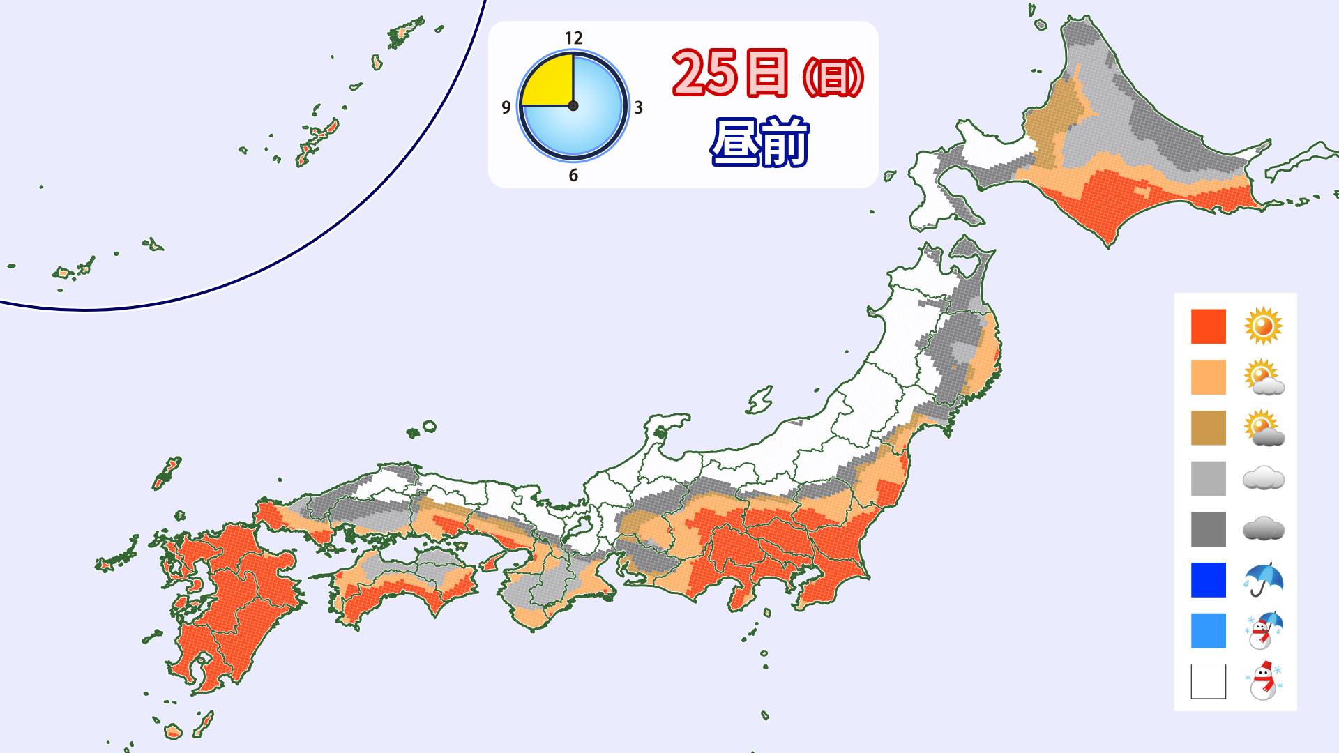
Through Sunday, January 25th
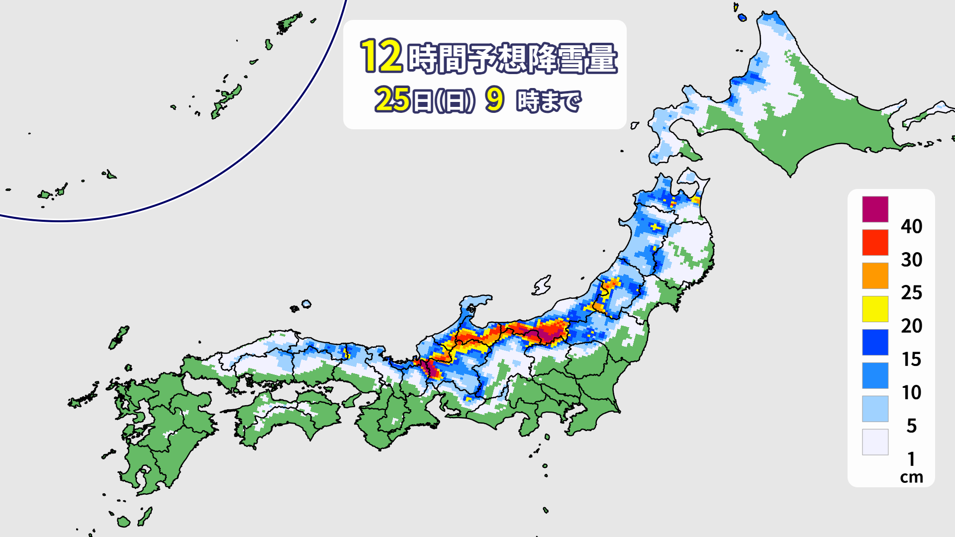
Starting the night of Saturday the 24th, a strong winter pressure pattern will return. Heavy snow is expected in some areas along the mountains from northern Japan to Hokuriku. The JPCZ is expected to weaken but move toward Kinki and Sanin. Fresh snow will be available across a wide area until the weekend
[Hokkaido area]
A small low pressure system will pass through the Soya region on the night of Saturday the 24th, and snow is expected to fall on Sunday due to westerly winds. Snow will accumulate mainly on the Sea of Japan side by morning, and snow will fall on and off during the day
[Tohoku area]
On Sunday the 25th, strong winter pressure patterns will be present again. Snow is expected to fall around the Ou Mountains. Winds will be strong, so please check the website to see if there will be any disruptions to lift operations
[Yuzawa area]
Starting on Saturday the 24th, the JPCZ will move south, and the northwesterly seasonal winds will strengthen. This means heavy snow is expected in the morning. How about finishing off your weekend with a little snow? Snow is expected to continue through the day on Sunday the 25th. The reset powder is likely to continue
[Shinetsu area]
The snow is expected to get heavier from the night of the 24th (Sat), with a large amount of snow expected by morning. As the snow continues through the day, it is expected to be a powder festival here as well
[Joetsu area]
The cold air will also intensify southward as the JPCZ moves south, with snow expected to continue through the morning
[Other areas]
It looks like the Kinki and Gifu areas will also see a lot of snow. Snow is also falling in the western Japan area, and the slopes are expected to remain in top condition until Sunday
lastly
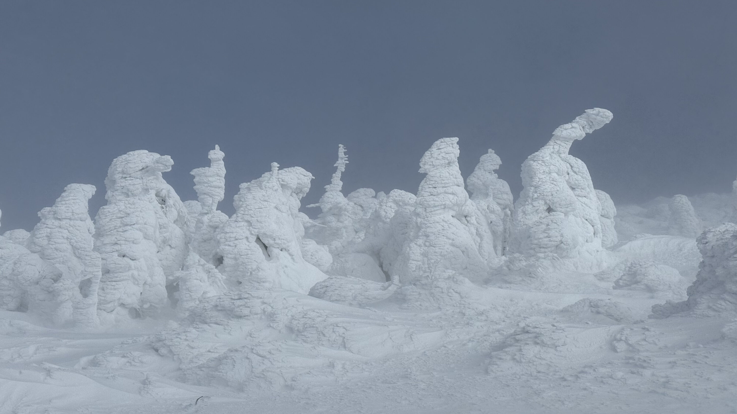
The cold wave will subside on Sunday, but cold air is expected to continue to flow in even after that. It looks like there will be many more exciting days this season. The photo shows the "Ice Monster" ice monsters I took yesterday (January 21st) at Zao Onsen Ski Resort. Thanks to the cold wave, they have also grown beautifully