
This weekend is a three-day holiday, where should you go skiing?! Tetsuji Hyodo, "Japan's best skiing weather forecaster," predicts the powder snow conditions over the weekend
Overview of this weekend

A winter-like atmospheric pressure pattern developed from last night through today, resulting in a significant amount of snow for the first time in a while, with about 20 to 30 centimeters falling mainly in the mountains. However, it looks like there will be very little snow this weekend, so this snow will be precious. Temperatures this weekend will be as high as or higher than last weekend, which will likely cause the snow to melt. Beware of avalanches in the British Columbia area. Also, this weekend is a three-day weekend, so let's take a look at the forecast through Monday
Through Friday, February 20th

A high pressure system will cover the entire country on Friday the 20th. In Hokkaido, the snowstorm is expected to end and the weather will be calm and sunny. Tonight on the 19th, we cannot expect any new snowfall, but the areas that snowed today will not be too warm, so the packed, compressed snow will be pleasant on the morning of the 20th. There may be some remaining powder on the sides


[Hokkaido area]
On Thursday, February 19th, about 20 centimeters of snow fell in Ishikari and Shiribeshi. No new snow is expected to fall tonight. Tomorrow, Friday the 20th, will be sunny with rising temperatures, so the snow will be packed down in the morning, but during the day, temperatures will drop to near 0°C in the lower elevation areas, causing some areas to loosen. There is a chance of snowfall in the southern part of the country in the afternoon
[Tohoku area]
High pressure will enter the prefecture, so it is expected to be sunny on Friday the 20th. In Aomori and Akita, there will be occasional snow or rain in the evening. It is unlikely to snow tonight. The snow will be firm in the morning, making groomed runs pleasant. However, there is a possibility of temperatures rising above zero during the day in the bottom areas. If you are looking for good snow quality, aim for higher altitude areas
[Yuzawa area]
It will be sunny on Friday the 20th. The snow will be firm in the morning. The temperature will rise above zero from around noon during the day, so the snow will likely loosen up quickly in the afternoon. It would be a good idea to apply water-repellent wax during your lunch break
[Shinetsu area]
On Friday the 20th, the snow will be firm in the morning, but the day will be sunny and the temperature will rise. The bottom area is likely to be above zero during the day, but the top area at a higher elevation may be below 0°C even during the day, so it looks like it will be in relatively good condition for skiing
[Joetsu area]
It will be sunny on Friday the 20th. The snow is expected to be firm in the morning. Temperatures will rise during the day. At lower elevations, temperatures will be above zero. Near the top of Hakuba, it may even be below 0°C, so it looks like the snow will be relatively stable and enjoyable to ski on
[Other areas]
On Friday the 20th, the morning will be chilly, resulting in icy conditions, but temperatures are expected to rise during the day, reaching over 5°C in some areas. Be sure to choose the right wax for wet snow
Through Saturday, February 21st

High pressure will move eastward in Japan, and warm air from the south will flow into Hokkaido. As a result, there will be areas in Hokkaido where temperatures will rise above zero. Sunny skies are expected nationwide


[Hokkaido area]
It will be sunny and cloudy. The temperature will be below zero in the morning, but will rise to above zero during the day, especially in the bottom area. It looks like spring skiing
[Tohoku area]
Particularly in the bottom area, areas where the snow loosened the day before will likely turn into ice. Be careful of accidents when skiing first thing in the morning. We recommend sharpening your edges well. During the day, temperatures will likely be above zero in southern Tohoku, even in the top area, and around 0°C in northern Tohoku. Be sure to adjust your wax properly
[Yuzawa area]
The high pressure will continue to cover the area and the weather will be sunny. The snow has loosened the day before, so it will be icy in the morning. The temperature will rise above zero during the day, so the snow will loosen again. Be careful not to make a mistake with your wax selection
[Shinetsu area]
It will be sunny. Temperatures may reach above zero during the day, even in high-altitude areas. If you're looking for good snow quality, it's best to go to a high-altitude area. It's time to bring in some wet snow wax
[Joetsu area]
It will be icy in the morning, but the day will clear up and the snow will loosen. This will be a recurring pattern, so be sure to sharpen your edges and switch to a new wax
[Other areas]
It will be sunny and the temperature will rise. In western Japan, some areas will likely remain above zero even at night. The snow will likely melt quickly. The skiable areas will likely shrink in some areas. Be sure to check the information on the slopes before you set off
Through Sunday, February 22nd

Warm, humid air will flow in around the edge of the high pressure system east of Japan, bringing rain to some areas, mainly in western Japan. Eastern and northern Japan are expected to remain sunny. The 0°C line around 1,500 meters above sea level is expected to move northward to Hokkaido

[Hokkaido area]
Warmer air is expected to move further north, with temperatures expected to reach above zero in Hokkaido. In sunny areas, the temperature on the slopes will reach around 5°C during the day, and the snow will loosen
[Tohoku area]
On the 22nd (Sunday), there will be ice in the morning, but the temperature will rise above zero during the day, causing the snow to melt. In southern Tohoku, temperatures may rise to around 7-8°C even in the top areas. As the snow melts, thin snow may appear in some areas
[Yuzawa area]
It will be sunny. There will be ice in the morning, and spring snow and granular snow during the day. Temperatures will exceed 10°C in some areas
[Shinetsu area]
It will be icy in the morning. The snow will loosen during the day. Be careful not to drive too fast in the morning
[Joetsu area]
It will also be icy here in the morning, but with temperatures exceeding 10 degrees Celsius during the day, it will turn into slushy snow. It's also a good idea to think about how to deal with pollen and other contaminants
[Other areas]
The temperature is high and it's full of spring snow. Rain is expected in some areas, especially in western Japan. Don't forget to take measures to repel water
Through Monday, February 23rd (national holiday)
A low-pressure trough and front are expected to pass through northern and eastern Japan in the morning. Strong southerly winds will blow across Hokkaido and Tohoku, and warm air of 3°C (1,500 meters) is expected to flow into Hokkaido at some point
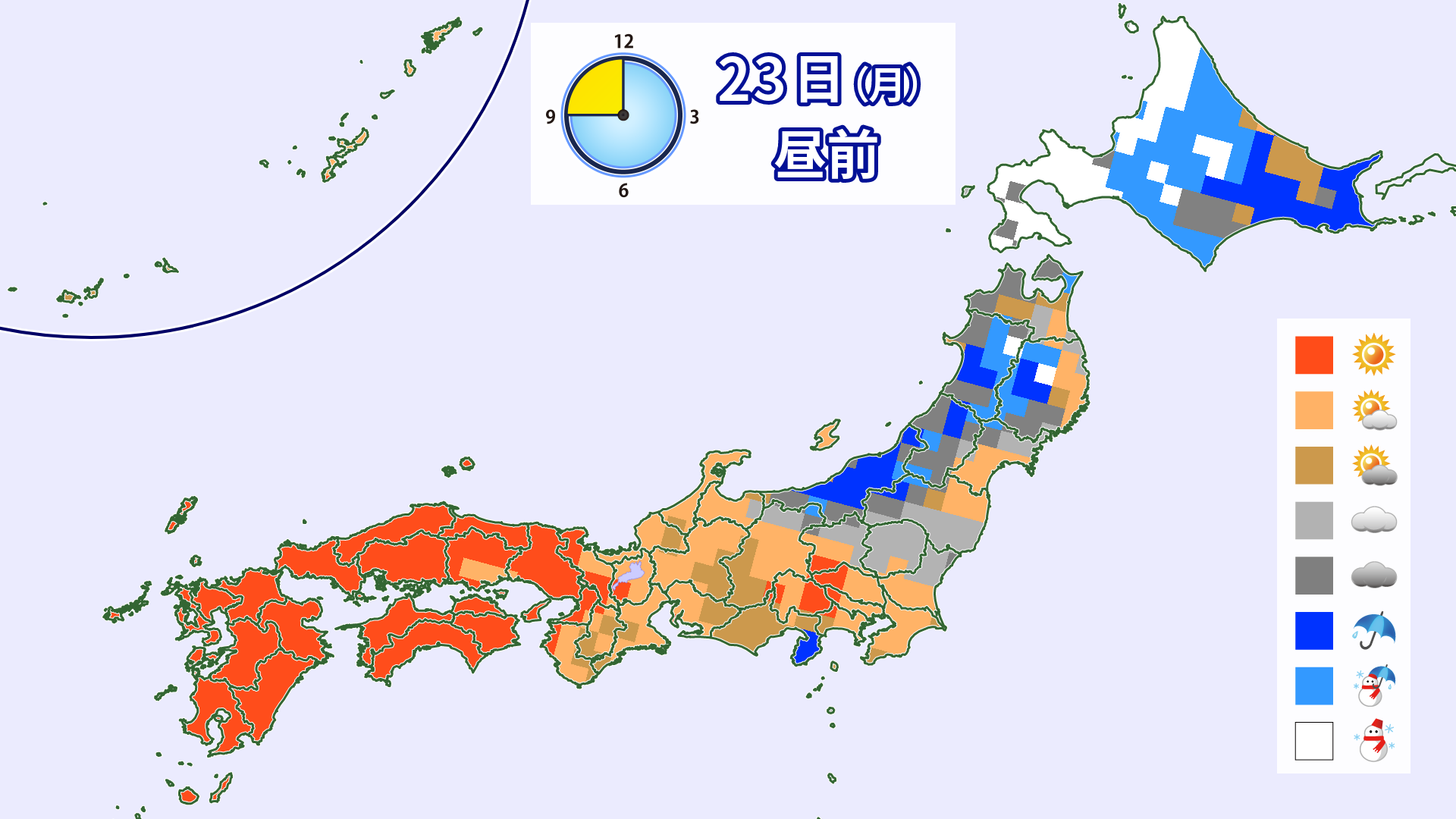
[Hokkaido area]
Warm air will flow in from the south, raising temperatures and bringing the possibility of rain in the morning. There will also be strong southerly winds. Around noon, a front will pass, causing winds to shift to the west, with rain changing to snow in some areas. Winds will remain strong. As the weather is expected to be rough, please check the opening times of ski resorts
[Tohoku area]
As the front passes through, strong southerly winds will blow from dawn to midday on Monday the 23rd, and there is a possibility that lifts may be closed due to the strong winds. Please pay attention to ski resort lift operation information. The wind is expected to shift to a westerly direction in the afternoon. Rain is expected from the early hours of the morning. The weather is likely to change to snow before noon, with snow expected to accumulate in some areas by the afternoon
[Yuzawa area]
It will rain in the morning, and will likely turn to snow in the afternoon. However, even if it does fall, it will be heavy and wet, and the temperature will not be too low, so it is unlikely to accumulate much
[Shinetsu area]
It will be mostly cloudy with a chance of light rain or snow from dawn to the morning. Temperatures on Monday, the 23rd, are not expected to rise as much as they did on Sunday
[Joetsu area]
Rain will fall in some areas from dawn until noon. It will then become cloudy. The rain will likely help melt the snow
[Other areas]
It will be cloudy or sunny in many places. Temperatures are expected to rise to around 10°C in some places, although not as high as on Sunday. Also, there is a possibility of yellow sand flying from Sunday night, mainly in western Japan. Don't forget to take measures against yellow sand

lastly
The Milan-Cortina 2026 Winter Olympics are finally reaching its climax. I think the snowboarding team's impressive progress is incredible. I'm also happy that my favorite mogul skier, Horishima, missed out on the gold medal, but won two medals, a bronze and a silver in the moguls and dual moguls. I was thrilled by his aggressive skiing until the very end
Well, this is the final installment of our regular weekend powder forecasts. Thank you to everyone who has always read our articles. We hope that it has been helpful to your snow life
It looks like there won't be any noticeable cold air moving south until the end of February. It feels like winter is coming to an end, but let's change our mindset and enjoy the second half of the season. I'm still going to go skiing!